Search

Custom Search

Friday, March 19, 2010

SHTTT Schedule Update

The SHTTT is pleased to announce upcoming plans for a new batch of highpoint achievements. As the summer climbing/vacation season approaches team members have set their sights on a large number of states and formal plans are advancing. You may wonder how decisions are made at the SHTTT so we'd like to give you an in-depth look at the bureaucracy of the team. There are many committees that decide the direction of the SHTTT. Here are the latest reports:

The central committee has agreed in principle to climb Missouri's Taum Sauk Mountain over the approaching Memorial Day weekend. It was determined that the inconvenient placement of this individual highpoint was not conducive to inclusion on any conceivable road trip. As such, a three-day weekend was thought to be the best time to complete this objective. Further plans are still developing and the matter was referred to the travel committee. The travel committee passed an initial request for aid in the central to northeast Arkansas/southeast Missouri areas. Interested parties should contact the SHTTT.

The scheduling committee has established preliminary date information for the Legendary Road Trip 2010. These dates are June 11-June 25 2010. The central committee referred the scheduling committee's report to the travel committee for consideration. The travel committee passed a general aid request for the entire southeast region of the United States. Upcoming central committee meetings will focus on exactly which states to include in Legendary Road Trip 2010 so that the travel committee may consider travel concerns involved.

The publicity committee reported that the SHTTT now enjoys 103 Facebook Fans and 119 Twitter Followers. The committee expressed concerns over the increasing irregularity of Hump Day Highpoint postings and suggested that the central committee seek to rectify this problem.

The travel committee reported an effort to consider the phenomenon of couch surfing as an aid to accomplishing the SHTTT's mandate.

The equipment committee foresaw no need for new equipment to accomplish either of the immediately upcoming events.

Wednesday, March 3, 2010

Hump Day Highpoint - Hawaii

After the Chilean earthquake which was so strong that it shortened the length of a day on Earth, there was much panic about tsunamis spawned in the Pacific Ocean. This was obviously mainly a problem for everyone's favorite archipelagic state, Hawaii. Standard procedure for approaching tsunamis dictates you head to higher ground and if you're in Hawaii the highest ground is 13,803 ft Mauna Kea:
Proud Mauna Kea advocates enjoy pointing out that when measured from their respective bases Mauna Kea is higher than Mount Everest rising as it does from well below the ocean floor. More rational people, however, are quick to point out that nobody actually measures mountains like that. Just like pretty much everything in Hawaii, Mauna Kea is a volcano though it is ok because it hasn't erupted for over 4000 years.

Mauna Kea is located on the island of Hawaii, which is generally called the "Big Island" to avoid general confusion. Big is, of course, a relative term as the island ranks 76th on the list of the world's biggest islands (Island Note: New Zealand is made up of two large islands. Because New Zealanders are not very creative the islands are named North Island and South Island). Once you get to the island the summit can be reached by road as there is a large observatory at the top. However, until recently rental car companies did not allow their vehicles on this road.
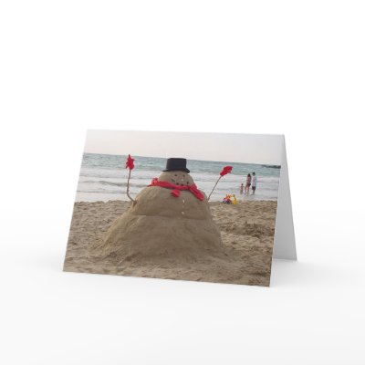
Interestingly, the peak of Mauna Kea is capped with snow in the winter making it possible to build a snowman in Hawaii that doesn't suck like this one:

Wednesday, February 24, 2010

More Lies from the Devils of the East

In the South, one is used to modesty in most things (except when it comes to The Merits of Texas), so it came as a shock when research revealed that West Virginia makes some bold claims concerning their geography. First off, "West" Virginia is so far East that one could hardly go much further without pitching straight into the ocean! It would be better named "Eastern-(but not as Eastern as regular Virginia)-Central-and-Slightly-to-the-North-kinda Virginia". It also contains the "New River" which is among the oldest rivers in the world.

Finally, E(BNAEARV)CASTTNK Virginia is also the self-styled "Mountain State". Naturally, a group concerned with climbing many mountains whilst consuming mind-impairing drugs thought this would surely lead to an extremely formidable State Highpoint. But no! The highest point in West Virginia is not a mountain at all. Instead, this braggart of a State has Spruce Knob instead. Knobs are found on doors, control panels, and old-timey beds, not mountains! I'll bet this "Knob" wasn't even created as part of an orgy! West Virginia relies on the fact that they have the highest average altitude east of the Mississippi to back up their claim.

I'm not totally down on West Virginia though. They did produce the youngest soldier of World War I and they produced (and are in fact still producing) the oldest and longest serving member of the US Senate. Finally, despite "Knob" being a quite suspect mountaineering term, the Spruce Mountain does actually have spruces on it! Also, in keeping with the tradition of putting things on top of things that are already tall, there is a tasteful observation tower from which one can see all the Spruces desired all the way down the mountains 4,863 ft.

Wednesday, February 17, 2010

Hump Day Highpoint - Special Highpoint Commentary

I would like to begin this week's Humpday Highpoint with an apology to all of our faithful followers, fans, and readers about the periodic failures to publish a weekly highpoint commentary. Please understand that sometimes team members are quite busy doing things like earning money for future highpoint exploits and sampling tequila. We only publish if we feel that we can provide a quality experience to you, the reader. Hopefully we can be more reliable in the future but hey, this entire endeavor is based around a beverage that tends to make me quite sleepy.

Today's Humpday Highpoint does not feature the highest point of a particular state. Instead we will focus on a certain phenomenon. I have noticed during the course of my climbing and writing about state highpoints a tendency to put slightly to severely phallic structures atop mountains. Before any analysis let us first establish the point with a collage:
In addition to these obvious examples, many states have built "observation towers" on their highest points. So why the abundance of such obvious signs of "masculinity" atop these points? In order to understand this, we must delve into the early days of exploration and a field which many people don't think much about; surveying.

Surveyors are tasked with establishing the location of points on the earth's surface. Of particular interest to our current line of inquiry, they measure the elevation of mountains. Modern technology makes this considerably less difficult but it was once a major undertaking. Just look at this guy:
As you can see, surveying can really excite you. When much of the country was still unexplored, surveyors were zealously rampaging through the country figuring out how high things were. Sigmund Freud suggests an unconscious fear that all men develop early in life known as castration anxiety. This is exactly what it sounds like and I must admit the suggestion makes me quite anxious. Because of this subconscious fear, early surveyors and the people who paid them devised a plan to reassure themselves in the face of this anxiety. They would strategically place reminders around the country that everything was okay. It only made sense that these would be placed at the highest points around for all to see. Women surveyors would no doubt have thought this undertaking pointless and silly. Fortunately for those men, woman surveyor sightings are a lot like catching a glimpse of bigfoot:
Joanne Darcy Crum, LSLinda Miller, PLS


Sunday, February 7, 2010

Team Member Rubbishes March Highpoint Rumors

A member of the State Highpoint Tequila Team of Texas has dismissed reports of an upcoming climb in Missouri or Arizona as wishful thinking: "We certainly would like to knock out those states sooner rather than later, but we have to pay the bills too." Citing concerns like "jobs" and "rent" the team insisted that activities in March would be limited to in-state training.

The team has been idle since the completion of their Epic Road Trip 2009 and some have started to question their commitment. "I just don't think they thought this through before they set off on their quest. People spend their whole lives trying to complete the 50 state highpoints even without an alcoholism element," said one skeptic who did not want to be named for fear of SHTTT retaliation.

Team members remain optimistic, however, about the upcoming summer and Legendary Road Trip 2010. "Certainly we are thinking about the summer and our planned coverage of the southeast. These sort of things require planning. We don't just go climb things willy-nilly."


Wednesday, February 3, 2010

North Carolinians Are Liars!!!

It may seem a sweeping generalization to call all the residents of a state liars but when it comes to highpoints you cannot trust North Carolina. The state is home to a large metropolitan area by the name of High Point. The only problem is that High Point, North Carolina is neither the highpoint of North Carolina nor is it anywhere near the 6366 ft Mount Mitchell that is the true highpoint. Don't skip High Point however or you'd miss the world's largest chest of drawers:
But enough about this den of lies and deception, we're supposed to be talking about actual highpoints. Mount Mitchell has many titles to its name including being the highest point in the country at one point (right up until TEXAS joined). It is the highest peak east of the Mississippi River. The mountain is named for one Elisha Mitchell and his grave lies atop the mountain:
Reverend Mitchell was a professor at UNC and at some point decided he would measure the height of the mountain that would eventually bear his name. Later in his life his measurements were challenged by a pesky Senator, forcing Mitchell to return to verify his data and defend his manliness. It was while doing this that he met his death. The Dictionary of North Carolina Biography describes the event thusly:
"Mitchell is best known for his measurement of the Black Mountain in the Blue Ridge and his claim that one of its peaks was the highest point in the United States east of the Rocky Mountains. He first noted in 1828, in the diary he kept while working on the geological survey, that he believed the Black Mountain to be the highest peak in the area. In 1835 and again in 1838 he measured the mountain, showing the highest peak to be higher than Mount Washington in New Hampshire's White Mountains. In 1844 he returned with improved instruments and measured the highest peak at 6,708 feet, 250 feet higher than Mount Washington. By that time local people were referring to the peak as Mount Mitchell. However, Mitchell's claim was challenged in 1855, when Senator Thomas Clingman, arguing that Mitchell had measured the wrong peak, insisted that the one he had climbed and measured stood at 6,941 feet. As a result of the ensuing controversy, Mitchell returned to the Black Mountain in 1857 in a final attempt to prove Clingman wrong and justify his own previous measurements. On 27 June, leaving his son and guides, he started out alone, was caught in a thunderstorm, and apparently fell down a waterfall and drowned in the pool below."

Clingman and Mitchell's dispute may have been settled but we all know what truly matters; getting stuff named after you. Because, though not yet featured on the Hump Day Highpoint, the highpoint of Tennessee is known as Clingman's Dome. This means that the two men are tied in terms of lasting glory. Fortunately history has seen fit to set things right....that deadly waterfall; Mitchell Falls.


Wednesday, January 20, 2010

Hump Day Highpoint - Massachusetts

No state has been in the news recently more than Massachusetts. All politics aside though, Massachusetts has a highpoint of its own; 3,491 ft. Mount Greylock. The origin of the name is unclear but it is clear that the mountain was once called Grand Hoosuck. In tribute to that original name, they built this atop the mountain:

The photo conveniently omits anything to reflect the scale of the tower. As such, I can only assume that it is HUGE. (Note: the tower is actually a veterans memorial)

Situated at the foot of the mountain, nearby Williams College annually celebrates 'Mountain Day.' Mountain Day occurs on a 'whenever the President feels like it' basis (though it is on some Friday in October). On Mountain Day, classes are cancelled and students are encouraged to 'commune with nature' (or not if they don't want to) by climbing the mountain. The SHTTT would like to endorse this activity but only with the expectation that Mountain Day must involve the consumption of considerable levels of adult beverages. Dining Services even serves a meal atop the mountain for anyone intrepid enough to make the hike (or ride the bus there since there is a paved road to the top). Perhaps in the future the SHTTT can crash Mountain Day and turn it into the party it has the potential to be.